Mawson’s scientific venture gets the credit it deserves as modern science seeks to understand what’s happening to the Antarctic ice sheet [17 January 2012 | Peter Boyer]

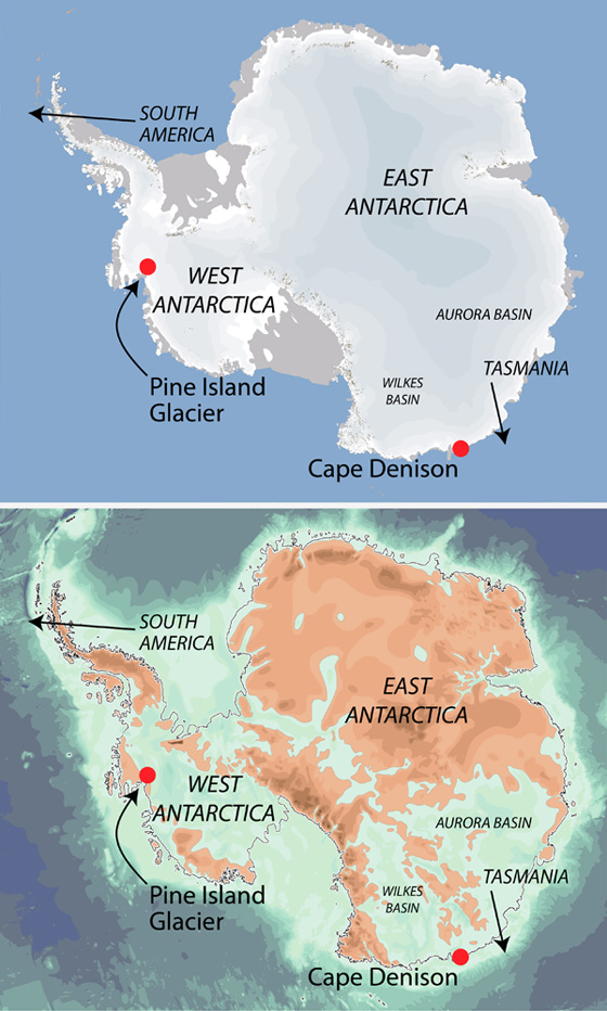
Antarctica with its great ice sheet (top) and without it (above), showing Aurora and Wilkes subglacial basins and the thousands of kilometres of coastline where ice is in direct contact with seawater.
A hundred years ago this summer, an expedition led by a South Australian geologist named Douglas Mawson made this country a world leader in the science of the far south.
As you read this, Australia’s ice research vessel Aurora Australis has just completed retracing the route of Mawson’s ship Aurora to Cape Denison, Antarctica, to celebrate the achievements of the 1911-14 Australasian Antarctic Expedition.
Mawson’s venture was a supremely successful scientific enterprise, bringing back more data on the geology, geography, biology and climate of the far south than any contemporary expedition — including those of Amundsen, Scott and Shackleton.
Last week Hobart-based scientist Steve Rintoul gave due credit to Mawson’s little ex-whaling ship Aurora which in 1912, under Captain John King Davis, was the platform for a major oceanographic voyage gathering Southern Ocean data between Hobart and Cape Denison.
The information gained from Aurora’s effort, notably its temperature and salinity data down through the water column, forms a baseline for current investigations of how polar waters south of Tasmania are responding to climate change.
Rintoul sees the region of very cold, very salty water off Mertz Glacier, near Cape Denison, as one of the “engine rooms” driving world ocean circulation, a role it shares with a handful of other sites off Antarctica and Greenland.
Ocean waters are the dominant influence on world climate, so getting a firm handle on how these waters are changing is an essential component of the vast global enterprise that is modern climate science. But there’s another pressing reason to be informed about Antarctic ocean waters.
How the Antarctic ice sheet interacts with ocean waters around it is playing heavily on the minds of Hobart-based scientists such as oceanographers John Church, Neil White and John Hunter and glaciologists Tas van Ommen and Roland Warner.
The Antarctic ice sheet, sitting on a rocky foundation around the South Pole, holds 90 per cent of the world’s ice — nearly 25 million cubic kilometres of solid water covering an area nearly twice the size of Australia. If there were no Antarctic ice sheet, seas around the world would be more than 60 metres higher than they are today.
The larger part of the southern continent, called East Antarctica because it’s mostly in the Eastern Hemisphere, is mostly based on a continental shield, once joined to Australia in a single southern supercontinent, Gondwana.
But West Antarctica and the part of East Antarctica that lies south of Tasmania (including Cape Denison) are by contrast peninsulas or archipelagos topped with a big slab of ice.
That means that a large part of the Antarctic coast is mostly not a rocky shoreline but rather the point at which the ice sheet ceases to be “grounded” on rock and starts to float on the sea. The ice sheet is thus in direct contact with sea water.
While Antarctica can change abruptly (such as in 2002, when the Larsen B Ice Shelf on the Antarctic Peninsula disappeared over a mere six weeks), the processes of change tend to be very gradual. If the ice sheet is to disappear again as it has done in times past, it will happen over a millennium or two.
But change can happen more quickly at a regional level, and a major driver of this is a warming ocean. Over the past few years scientists have paid special attention to a part of the Antarctic coast where a large glacial stream enters the Amundsen Sea, southwest of South America.
The Pine Island Glacier drains the part of West Antarctica at the base of the Antarctic Peninsula. Satellite images reveal little of what’s going on, because all the action is out of sight, about 1000 metres below the ocean surface.
A US-British investigation using a robotic submarine has found that in 2009 alone about 80 cubic kilometres of Pine Island Glacier was melted by warmer incoming seawater. Over a 35-year period the glacier’s rate of flow to the ocean has increased by 70 per cent.
Like Mawson before them, van Ommen and Warner are studying the East Antarctic ice sheet — specifically, how it works and how it changes over time. They’re especially focused on two large subglacial basins, Wilkes and Aurora (the latter named after Mawson’s ship) extending deep into the hinterland south of Cape Denison and Australia’s Casey station.
As with Pine Island Glacier, the Antarctic coast north of Wilkes and Aurora Basins is defined mostly by the grounded ice sheet, putting hundreds of kilometres of ice into direct contact with seawater. This may deplete and potentially destabilise the ice sheet.
Aerial surveys of the ice of Aurora Basin over the past couple of summers are the start of a big research project to define how far seawater might intrude under the East Antarctic ice sheet. What they and their international colleagues uncover will help White, Church and others determine the likely rate of sea level rise over coming decades and centuries.
The last big survey of climate science, the 2007 IPCC report, was conservative about the influence of the big ice sheets on sea level because we didn’t know enough about how they worked.
Since then, as well as the Pine Island Glacier and Aurora Basin studies, we’ve benefited from an array of satellite-based tools for measuring surface and mass fluctuations of the Antarctic ice sheet.
These research projects are getting us closer to the point where we can state definitively how Antarctica is changed by the climate, and how Antarctica, in turn, will affect the level of our seas.
