Ever-more urgent warnings about the state of the climate are coming from our oceans. [19 June 2012 | Peter Boyer]

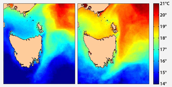
Comparison of satellite temperature data from 1994 (left) and 2012 (right) shows marked warming in Tasmanian waters [Alistair Hobday, CSIRO]
Perhaps not. Nearly all the public debate on climate impact limits itself to dry land: the part of the planet with houses and cities, roads and cars, forests, fields and deserts. In doing so it leaves out roughly 70 per cent of Earth’s surface.
It’s perfectly understandable that we overlook the oceans. Over millions of years we evolved in the jungle and savannah of continental Africa. While we sometimes dip a toe in the sea, the land remains our home and our main focus.
Australians are no exception. Environment minister Tony Burke’s announcement last week that Australia would have the world’s most ambitious national marine reserve system is a major policy initiative that needs widespread and prolonged public debate.
But we probably won’t get that. Most Australians find enough to occupy their attention on terra firma, and don’t put a high priority on what happens offshore.
Unlike mainlanders, a high proportion of Tasmanians can see the sea from either their homes or a short distance away. None of us is more than a couple of hours by car from the coast. If we want to leave our state, we must cross 250 km of water. Like it or not, the sea is part of our lives.
That probably helps explain the success of a 2009 initiative to get the Tasmanian public to help work out how climate change is affecting the marine environment. The interactive website “Redmap.org.au” is the brainchild of Dr Gretta Pecl, a marine ecologist with Hobart’s Institute of Marine and Antarctic Studies.
The “red” in Redmap stands for “Range Extension Database”. The idea is that species discovered outside their normal range — say NSW species occurring in Tasmanian waters — are a good indicator of how marine conditions are changing. Fishers are asked to upload data about their catch, with a photograph, to the Redmap website.
The scheme has succeeded beyond expectations. Contributors have logged more than 400 sightings of over 70 marine species, many spotted outside their normal range. Sightings have been included in three scientific papers while helping Redmap score some awards along the way.
Now a revamped Redmap is going national, with help from the Australian National Data Service, the federal fisheries department and a $300,000 grant from the federal government’s “Inspiring Australia” initiative.
The Redmap team plans a national launch in time for next summer’s fishing season, allowing all Australians to record sightings and photos of unusual marine species. The new Redmap will allow input from both desktop and portable internet devices, while offering an Australia-wide network of scientists to help identify species.
Recent work by CSIRO’s Alistair Hobday helps to explain why so many mainland species are turning up in colder Tasmanian seas. His comparison of 1994 and 2012 satellite temperature data showed marked warming in waters to Tasmania’s east and northeast.
Hobday’s findings reinforce the evidence from a 68-year data set from Maria Island waters, compiled by Katy Hill, of Hobart’s Integrated Marine Observing System, which revealed Tasmanian waters are warming at a rate of over 2C a century, making them a global hotspot.
“Global hotspot” could equally describe Tasmania’s current prominence in global ocean science. A study of ocean salinity by Paul Durack, a University of Tasmania graduate now with the Lawrence Livermore National Laboratory in California, and two Hobart CSIRO scientists, Susan Wijffels and Richard Matear, has potentially massive implications for all climate science.
Containing 97 per cent of the world’s water, the global ocean receives 80 per cent of all surface rainfall and has absorbed 90 per cent of the energy from past atmospheric warming. As Matear puts it, “the ocean matters.”
A warming atmosphere, which can hold more water, strengthens the global rainfall and evaporation cycle (the water cycle) leading to more intense extreme events, with stronger winds, wetter rains and more intense droughts.
In finding clear changes in salinity patterns in the global ocean over the half-century to 2000, the study has found that the water cycle may be strengthening at a rate far exceeding what science had previously calculated.
The strength of the water cycle is best determined by ocean temperature and salinity data. Most current scientific modelling of future climate is based on an acceleration of around 2 per cent over the 50 years to 2000.
But there’s strong evidence in the Durack-Wijffels-Matear paper, published in the international journal Science, that the water cycle has strengthened at double that rate. Based on the expected 21st century warming of 3C, this would result in a water cycle up to 24 per cent stronger by 2100.
We’d do well to suspend our quibbles over the urgency of cutting carbon emissions, and instead to ask ourselves, how would our descendants manage a 24 per cent increase in the intensity of storms and droughts?
