A significant increase in Antarctica’s contribution to sea-level rise raises the prospect of a 1 metre to 1.8 metre sea level rise within a human lifetime. That should be raising alarm bells among authorities and planners.

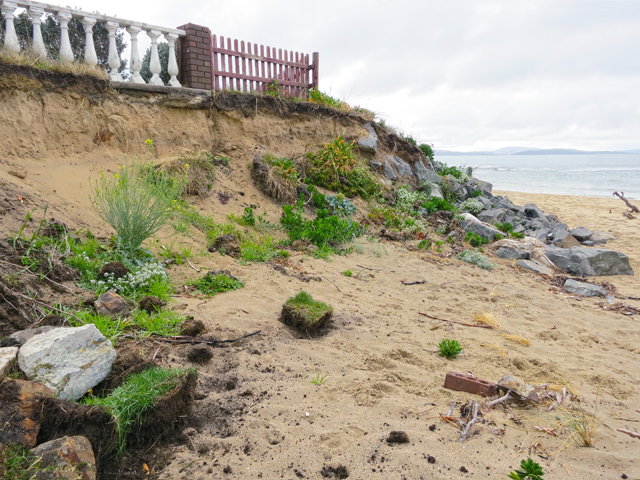
Roches Beach has been losing sand steadily since about 1980.
A giant is stirring to our south. It will be centuries before the giant is fully awake, but when it is people will wonder why this massively important event took so long to register.
The giant is, of course, Antarctica, or more specifically the Antarctic ice sheet, which contains over two-thirds of the world’s fresh water and over 90 per cent of its ice.
In its latest scientific report four years ago, the Intergovernmental Panel on Climate Change calculated that most of the estimated half to one metre of global sea level rise by 2100 would come from melting on Greenland. Antarctic ice melting would add just a few centimetres.
But since then a lot has happened. A 2015 paper in in the journal Nature supported the view that the IPCC conclusion was too conservative, and that business-as-usual emissions would cause melted Antarctic ice to add as much as 39 cm to sea level by 2100.
A 2016 Nature paper projected that continuing today’s emissions trend would cause enough melting of Antarctic coastal ice cliffs and buttressing ice shelves to trigger their disintegration.
In that case, about 80 years from now with atmospheric carbon dioxide about double today’s level, Antarctic ice would have added as much as a metre to sea levels, making global mean sea level about 1.8 metres higher than today and continuing to rise at an increasing rate.
Addressing the 2017 Antarctic Treaty meeting in Beijing, leading New Zealand glaciologist Tim Naish said new modelling showed that keeping industrial-era warming below 2C would help protect coastal Antarctic ice shelves and keep Antarctica’s sea level contribution to less than half a metre.
Which means that the best possible outcome at the end of an average Tasmanian lifetime, starting now, is that seas will be about a metre higher than they are today, while unabated emissions will see a 1.8 metre rise. Either way, this is an awesome challenge to good governance and planning.
After being relatively unchanged over 2000 years, for the past 100 years global sea level has been rising at an increasing rate. In the 20 years to 2014 global sea level rose at an average rate of 3 mm a year, but the present rate is about 3.4 mm a year.
These are difficult things to study. Distinguishing normal ebbs and flows from the baseline shifts that mark a sea change requires painstaking analysis of multiple forces – not just tides, waves, currents and winds, but also vertical movement of land and even gravity itself.
Sea level looms large in the lives of University of Tasmania specialists Christopher Watson and Chris Sharples, whose otherwise quite distinct academic careers coincide on the question of how our dynamic world’s oceans are changing land-sea boundaries, or coasts.
Watson is a geodesist, studying Earth’s size, shape and gravity field. This is a moving target. As he explains, “all parts of the Earth system are constantly in motion; mountains are still being formed, continents are being reshaped, and the oceans are transporting heat all over the globe.”
His main research focus is on more accurately measuring the Earth system and by these means better understanding sea levels and how the massive exchange of water between the oceans, atmosphere, continents and ice sheets is responding to continuing warming.
Sharples came to the matter of rising sea levels as a geomorphologist, studying the changing forms of land and sea floors. A longish lifetime in Tasmania has given him special insight into how this island responds to the assaults of water, wind and living things, notably humans.
While honing his skills over decades in the field, Sharples never got round to acquiring the formal prerequisite for an academic career, a doctorate. He is now doing just that, with the much-younger Watson as a supervisor. I suspect they teach each other.
The question Sharples asks in pursuing his PhD is whether we can yet see physical responses to sea level rise in Tasmania’s soft coastal landforms, made mainly from sand, soil and erodible rock.
His project involves identifying coast types that have changed most in the past 70 years and ascertaining the cause of that erosion. In particular, he is looking for any sign that rising global sea level is a factor in shoreline retreat.
Sharples has found evidence of Tasmanian beaches responding early to sea-level rise, including Ocean Beach on the West Coast and Roches Beach in the South-East. In each case storm events are reaching steadily higher on the beach because its sand is being transported elsewhere.
He has identified another class of “early responder”: soft-rock shores in swell-sheltered waters, such as Barilla Bay in Pittwater, whose clay-based shore has been retreating since about 1980.
Until the trend toward general shoreline retreat becomes clearer, the insights of Watson, Sharples and scientists like them are our best guide. In the meantime our future coastlines are already being determined by the amount of carbon dioxide we’re releasing into the air.
Which leaves two obvious policy imperatives: plan for coastal inundation and – to prevent this from becoming a disaster along with many other things including human health – cut carbon emissions.
Four weeks from Saturday Tasmanians will choose a new government. Saying climate change ought to be front and centre in the campaign is surely stating the bleeding obvious.
