A few months ago, a strong El Niño event later this year seemed certain, but no longer. What’s happening? [5 August 2014 | Peter Boyer]

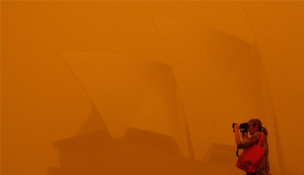
Sydney in a dust storm in September 2009, during the most recent El Niño event. PHOTO ROB GRIFFITH, ASSOCIATED PRESS
Every now and again we get a reminder of our place in the scheme of things. One such event for me was in 1987, in my first crossing of the Southern Ocean.
Aboard Australia’s veteran supply ship Nella Dan, we were headed south for Antarctica after a spectacular sunset over Heard Island. We didn’t know it then, but this would be that ship’s last completed voyage before it grounded at Macquarie Island and was scuttled.
Around that time I recall reading an Eric Newby tale about a windjammer travelling around Cape Horn. On the Southern Ocean, where the wind blows around the globe unimpeded by land, Newby described swells like no other, spanning a quarter of a mile from trough to trough. Here I was in that very ocean.
After a nauseous fortnight the ship’s company was looking forward to calmer waters in the sea ice, but that night a storm blew up. I got tired of rolling and sliding in my bunk and went up to the bridge to see what was happening. My moment of truth came when I looked out to see, in the ship’s headlights, a wall of water towering above us. It had to be at least 20 metres high.
Arne Sorensen, Nella’s master, seemed calm enough, but from where I stood we seemed destined for oblivion. I forgot about feeling seasick and just hung on and watched, transfixed by the mighty spectacle, until dawn broke, the wind dropped and the sea ice stilled the waves.
We use terms like unfathomable or deep as the ocean when we talk of mysteries, because the oceans are Earth’s greatest mystery. We’re well-placed to appreciate this down here in the roaring forties. Tasmania has some of the most unpredictable weather on the planet. We’re slowly making sense of it, learning to unravel the patterns of oceanic weather systems like the one that gave us last week’s storms, and pieces are being added to the jigsaw all the time.
Conditions in three oceans dominate Australian weather: the Pacific, the Indian and the one that joins them together, the Southern, whose rain-providing westerly winds are gradually heading southward leading to long-term drying of southern Australia. But the big one is ENSO, or the El Niño Southern Oscillation. ENSO happens in the equatorial Pacific Ocean, but it has an effect right around the world. Its most direct impact is felt in adjacent countries including Australia (where it is associated with droughts and floods) and the United States.
Most of the time, ENSO is in a neutral or negative (La Niña) phase. During a La Niña, surface waters in the eastern Pacific are cool and the atmosphere in the western Pacific is warm and moist. At these times eastern Australia is most likely to get flooding rains and intense cyclones. But once every few years, for reasons still unclear, this situation reverses. A warming of surface waters off Peru (El Niño) extends westward at the same time as high atmospheric pressure predominates over Indonesia and the western Pacific (the Southern Oscillation).
During our winter, an El Niño brings generally drier conditions across Australia, New Guinea and Indonesia, as far west as India and in central America and the Caribbean, while it’s wetter in Chile and the central Pacific. In our summer it’s hotter here while the US is wetter. An El Niño can be less than a year long, but sometimes extends over two years. Some El Niño events, such as in 1982-83 and 2002-03, can trigger intense and prolonged drought in Australia. Others, like the 1997-98 event, cause a strong rise in global temperature.
While science has found common patterns, each ENSO event is different. They are hugely complex, with ocean and air conditions combining in infinitely variable ways and involving trade winds, ocean circulation and a host of other atmospheric and oceanic conditions. El Niño is known to have a warming influence, yet we didn’t have one in June when the global average temperature was the highest on record for that month, or for the January to June period which was the third warmest such period on record.
Understanding El Niño is a work in progress, which has become very obvious over the past few months as scientists try to understand the very mixed messages coming from sea surface temperatures and atmospheric pressure over the Pacific. Is an El Niño coming, or isn’t it? Early this year strong surface warming in the Pacific off Peru produced signs very similar to the lead-up to the powerful 1997 event. It seemed all but certain that we were in for another strong El Niño event, with drier, warmer conditions on our side of the Pacific and flooding in the Americas.
The trend continued through to April, but then some anomalies cropped up. The warming waters stopped expanding as signature westerly winds from Indonesia into the Pacific that persisted through the early months of 2014 unexpectedly dropped away. A month ago meteorologists were still saying it was more likely than not that an El Niño would happen later this year, but now that’s been trimmed back to a 50-50 chance. What’s going on, and how might this affect Australian weather?
No-one is better qualified to talk about ENSO than Neville Nicholls of Monash University’s School of Earth, Atmosphere and Environment. He has studied the phenomenon for over 40 years and is now a world authority. In Hobart tonight, in a public lecture at the University of Tasmania’s Stanley Burbury Centre hosted by the Australian Meteorological and Oceanographic Society, he will offer his insights into what ENSO has in store for us over the next year or so. The event starts at 6 pm.
